Bude’s Geology
Guided Bude Geology Walks: Check the schedule here…
If you take a walk on the beaches or along the cliff path in either direction from Bude you can not fail to notice the striking and impressive rock formations everywhere you look!
Basically, the so called “Bude Formation” of North Cornwall is such a fine example that is has been studied by generations of geologists. The sand and mud layers were deposited in a giant tropical “Lake Bude” 300 million years ago. These layers were eventually folded when Britain and France collided. This was so long ago, that the Dinosaurs were yet to evolve!
We are very proud of Bude’s very unique fossilised fish which is found nowhere else in the world. Fossils are hard to find in Bude, but this toothy, goldfish-sized fish called Cornuboniscus budensis is on display for all to see at the Bude Castle Heritage Centre. The fish is evidence of a life form from an era when Bude’s climate was similar to modern day Africa.
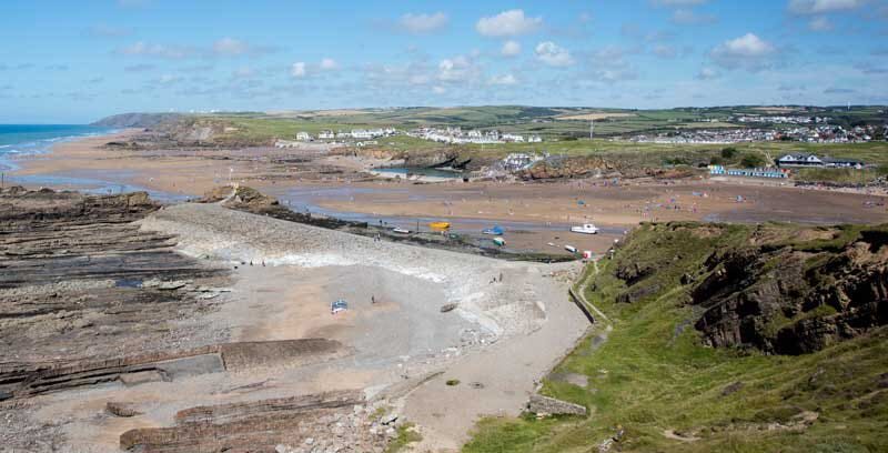
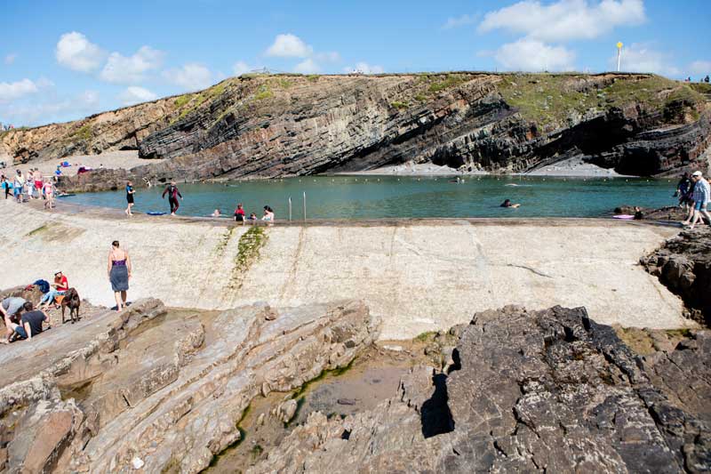
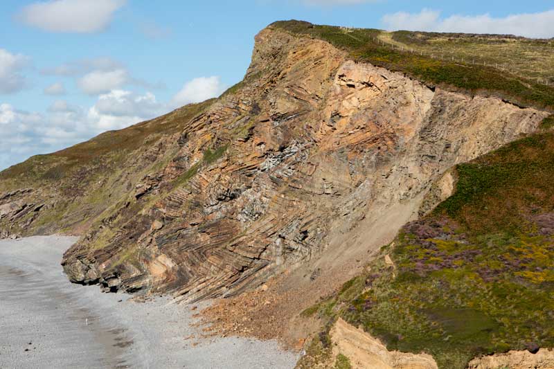
Bude coast, looking north from Compass Tower. Note Bude Sea Pool in upper centre, beyond the yellow boat. Alternating beds of sandstone and mudstone (aka shale) totalling 1.3 km in thickness, known as the Bude Formation, are superbly exposed for many kilometres along the cliffs and in the wave-cut platform, attracting geology students and professionals alike. About 300 million years old (Carboniferous Period of the Palaeozoic Era), these beds were deposited as soft sand and mud in a tropical ‘Lake Bude’, home to a globally unique fish, Cornuboniscus budensis, an exquisite fossilised specimen of which is displayed in Bude Castle museum. Accumulation of such a great thickness of strata (1.3 km) was accomplished by subsidence. The beds were then deformed into spectacular zigzag folds (‘chevron folds’) by collision of England and France, which uplifted the whole of Cornwall to form a mountain belt, in latest Palaeozoic time, before dinosaurs existed.

Southward view over Maer Low Cliff Beach from Maer High Cliff top. The V-patterns made by resistant upstanding Bude Formation sandstone beds in the wave-cut platform (partly covered by beach sand) indicate that the beds are folded into a seaward plunging syncline (downfold) and adjacent anticline (upfold). Note Bude cricket ground at top left and Bude Sea Pool to the right of it.
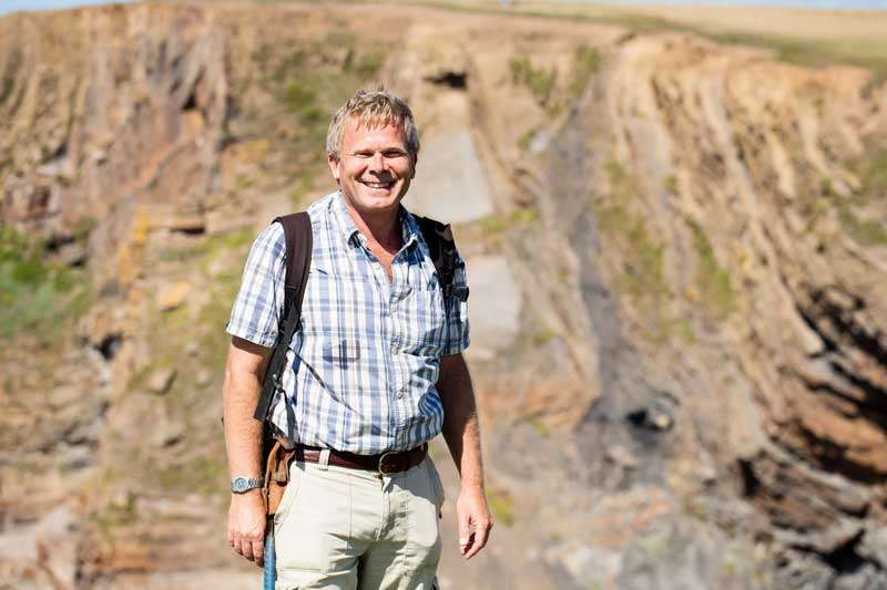
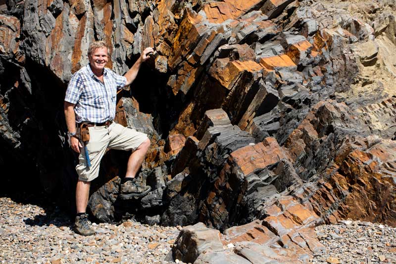
Bude geologist Dr Roger Higgs, who wrote the captions for this series of photographs. The background cliffs are of Bude Formation folded sandstone and shale beds at Efford Ditch (see next two photos).
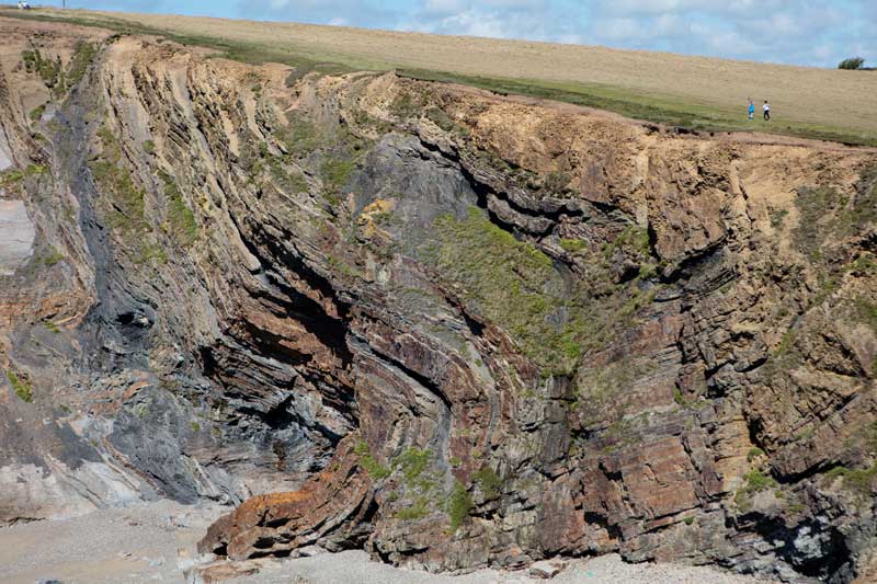
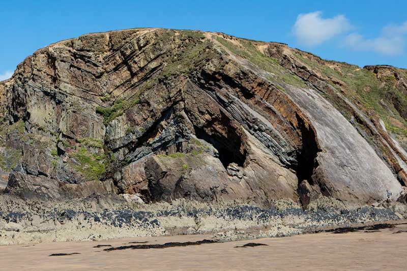
Strongly folded sandstone and shale beds of the Bude Formation at Efford Ditch, looking northeast. People on cliff top for scale. The strata on the right dip to the right, and those on the left to the left, defining an anticline (flanked by a syncline in the far right; close-up in next photo).
Close-up of previous photo’s right half. Bude Formation sandstone beds appear rusty brown due to a coating of iron oxide on fracture surfaces. Darker shale beds are more recessive, i.e. softer (more easily eroded).
Bude Formation exhumed anticline known as ‘Whales Back’ (1963 Ordnance Survey map, 6 inches to 1 mile scale), immediately west of Bude breakwater, looking west. The near end, truncated by erosion (bombarded by shingle carried in storm waves), exposes alternating beds of sandstone and dark shale.
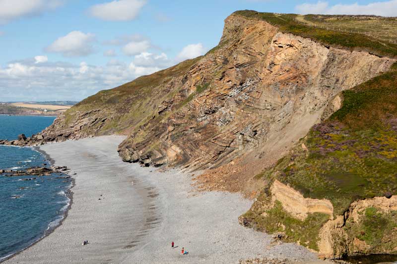
Bude Formation sandstone and shale beds folded into a syncline and adjoining anticline. Maer High Cliff, looking northeast. Man for scale at far right, near cliff base.
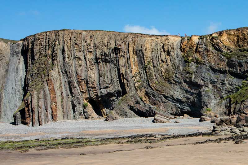
Steeply dipping folded Bude Formation sandstone and shale beds. Maer High Cliff, looking east. People on cliff top for scale.
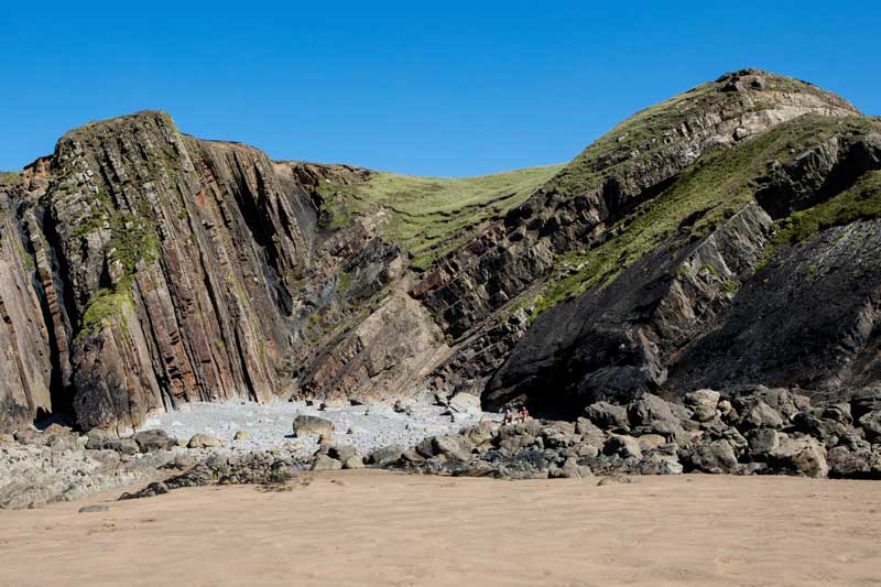
Bude Formation sandstone and shale beds folded into a syncline. Pearce’s Cove, looking east. For scale, note two men seated on beach boulder.
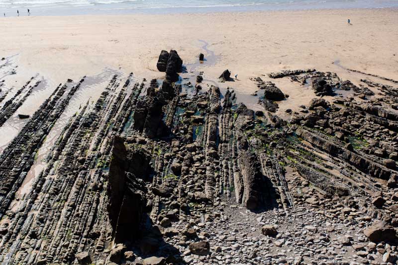
View from Maer High Cliff top, looking west. People on beach for scale. The wave-cut platform exposes upstanding ribs of Bude Formation sandstone (harder to erode); thicker sandstones locally form sea stacks. In the right half of the photo, the ribs are folded into V-shapes pointing seaward. This pattern, and the outward dip on either side of each V, indicate that the fold is an anticline (upfold) plunging seaward. Such 2D horizontal cross sections through Bude Formation folds complement the vertical cliff sections, allowing the folds’ 3D geometry to be discerned.
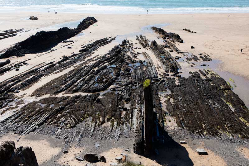
View from Maer Cliff top, looking west. People on beach for scale. On the wave-cut platform (partly covered by beach sand), Bude Formation sandstone ribs dip left and right on either side of the centre line (top to bottom), defining an anticline. The ribs meet in a V-shape at the centre, indicating that the anticline plunges seaward. Note sandstone sea stack in foreground.
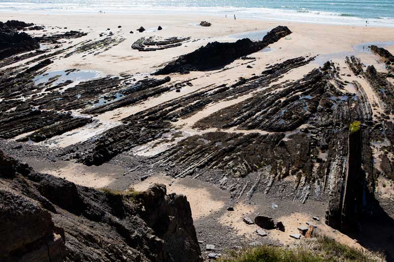
View from Maer Cliff top, looking southwest. People for scale, near water’s edge. On the wave-cut platform, the V-patterns and opposed dips of Bude Formation sandstone ribs reveal two seaward-plunging folds, namely an anticline (right-hand side; close-up in previous photo) and adjoining syncline (upper left).
Bude Sea Pool, looking east. In the foreground and background are Bude Formation sandstone and shale beds dipping north, in the north limb of an anticline and south limb of a syncline.
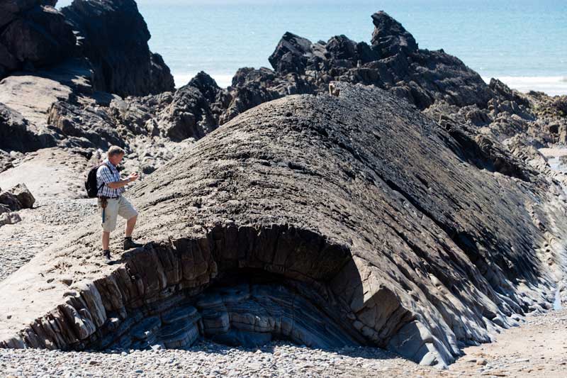
Bude geologist Dr Roger Higgs at First Cove. Bude Formation sandstone and dark shale beds dip inward toward the centre of the view, defining a syncline. The next few photos show some of the ‘sedimentological’ details of Bude beds, helping us to interpret the ancient ‘environment of deposition’. The scarcity of fossils and burrows, and the presence of a unique fossil (a fish), suggest a lake (called ‘Lake Bude’ in geological publications by Roger) rather than a sea. Palaeomagnetic studies show that the latitude was equatorial, consistent with tropical plant fossils in the Coal Measures (same Carboniferous age) of South Wales.
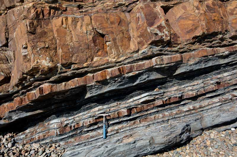
Bude Formation sandstone and dark shale beds in the low cliff at Summerleaze Beach (north side). Sandstone beds have sharp bases and many of them have rippled tops, e.g. the bed under the hammerhead (which is the lowest bed in the next photo). The ripples are nearly symmetrical, suggesting that waves contributed to forming them, in turn suggesting deposition in water less than 200 m deep.

Bude Formation strata at Summerleaze Beach (north side; enlargement of previous view). Three sandstone beds alternate with dark shales. Each sandstone has a sharp base and a less-sharp top showing near-symmetrical ripples. To the right of the £1 coin (for scale, 22 mm across), the second sandstone bed is cut by a vertical, mud-filled, cylindrical burrow (dark grey), made about 300 million years ago by a probable worm or shrimp digging into the soft sandy floor of ancient ‘Lake Bude’ (see enlargement, next photo).
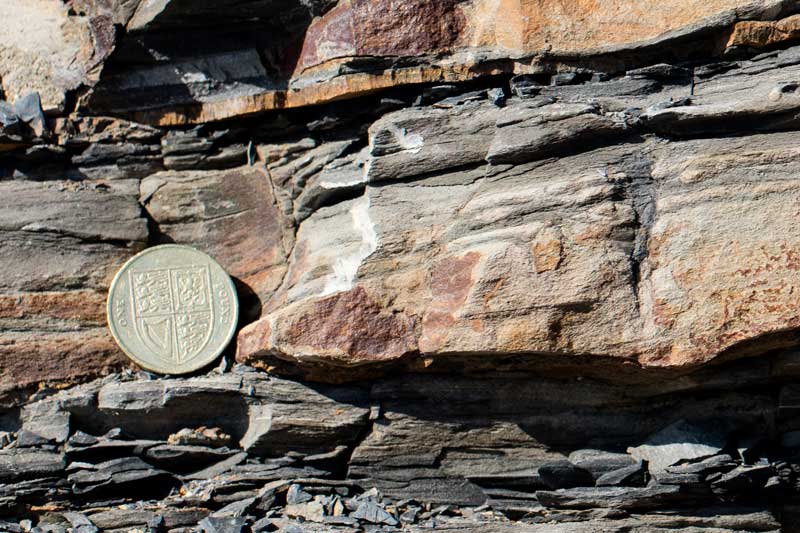
Bude Formation strata at Summerleaze Beach (north side; enlargement of previous photo). Close-up of a burrow (right hand side) excavated in a soft sand bed by a Palaeozoic lake-floor animal and filled by dark grey mud after abandonment.
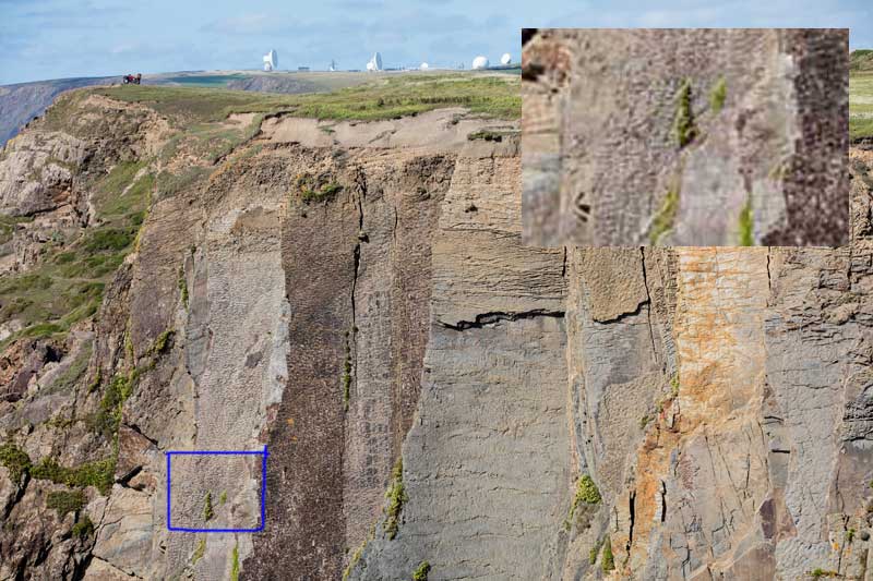
Upper portion of Maer High Cliff, looking north from cliff top. Quad bike for scale at upper left. The top surfaces (facing south) of several Bude Formation near-vertical sandstone beds, exhumed by erosion of intervening shales, show ripples in plan view. The ripples were made in soft sand on the flat floor of ‘Lake Bude’ about 300 million years ago.
Millook Haven, 7 km south of Bude. Note South West Coast Path (cliff top, upper right) and people on beach for scale. Sandstone and shale beds of the Crackington Formation have been spectacularly deformed into a vertical cascade of zigzag folds (anticlines and synclines), lying on their sides. See enlargement, next photo. The Crackington Formation is similar to the Bude Formation (which was deposited immediately above it, before the folding took place), but lacks the very thick (3-10 m) sandstone units typical of the Bude. The photo of ‘chevron folds’ in Wikipedia is from here.
Zigzag folds in Crackington Formation at Millook Haven (enlargement of previous view). For scale, note lady on beach at lower left.

Bude Park and Ride 2026
The Bude Park and Ride operates 18 July – 31 August 2026 calling at The Strand, Summerleaze Beach and Crooklets Beach.
Bude: The UK's first Food Allergy Safer Town
Something remarkable is beginning to happen here in Bude. Cafés, restaurants and hospitality businesses are coming together with one shared goal: to make Bude the UK’s first Food Allergy Safer Town (FAST), powered by Safe Serve Flags.
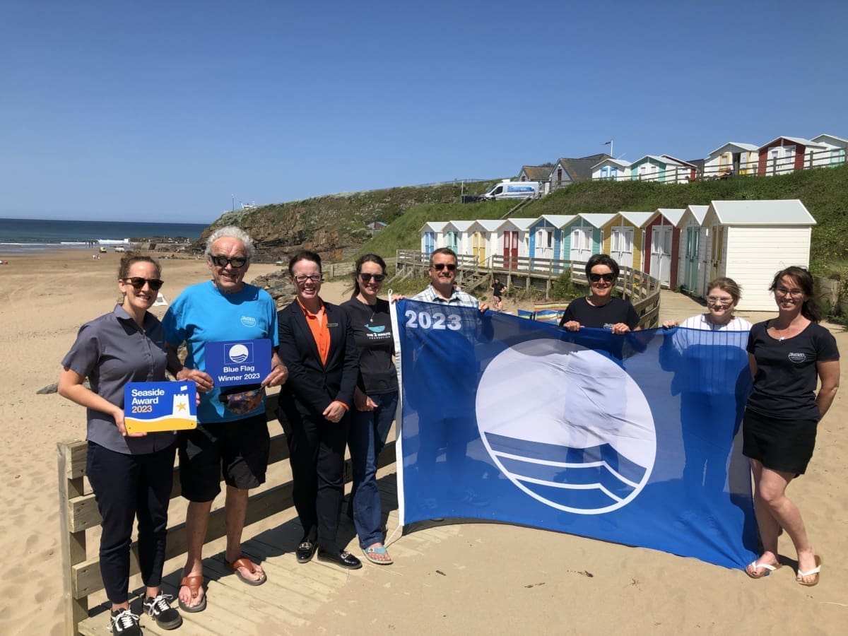
Blue Flag Beaches in Bude
Bude has done the triple! Three of our much-loved beaches – Widemouth Bay, Crooklets, and Summerleaze – have been awarded both the prestigious Blue Flag and Seaside Awards.
Meet the Bude Artists Opening Their Doors for Cornwall Open Studios 2026
Discover Bude’s vibrant art scene during Cornwall Open Studios 2026. Meet five local artists opening their studio doors and explore galleries, with two other Bude artists from Sue Read and Harry McConville.

The Ultimate Guide to Pubs in and Around Bude: Where to Drink, Dine & Unwind
Looking for a traditional pub serving the perfect pint in Bude? This complete guide covers pubs in and around Bude including countryside inns—with food and dog-friendly options.

Best Roast Dinner in Bude
Looking for a Sunday lunch in Bude? We have a great selection of pubs and restaurants in and around Bude, so you’ll easily find something to suit your taste and budget. These are some of our favourites!

Best Cornish Pasty in Bude
Wondering where you can get the best Cornish Pasty in Bude? Look no further! In the name of research and geat customer service, we’ve been to the bakeries in Bude and purchased a traditional Cornish Pasty to find out.

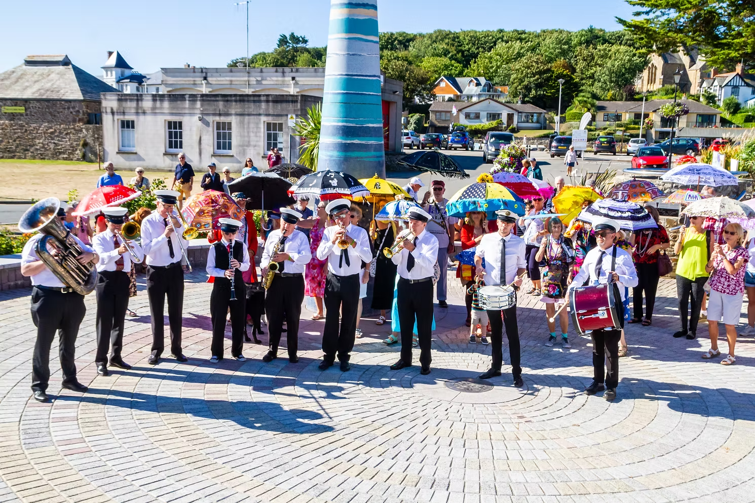
The Bude Jazz Festival
Every year, the sound of swing, blues and New Orleans rhythms fills the streets of Bude as the Bude Jazz Festival returns to the town. Taking place from 1–4 September 2026, the much-loved event will once again bring four days of live music, vibrant performances and a wonderfully welcoming atmosphere to Cornwall’s north coast.